Conner did not wash ashore
Fundamental to the State's case against Scott Peterson is the claim that Scott put a still-pregnant Laci, anchored with weights, into the Bay on December 24, 2002, and that a storm on April 12, 2003 loosed Laci from her anchors and Conner from within Laci, and allowed them both to be washed ashore.
In the opening paragraphs of the State's Closing Arguments, Distaso plainly stated the importance of connecting Scott's fishing trip to the location where the bodies were found:
The most important fact in this case, go ahead and click on "common sense", the most important fact in this case is, and the one fact that cannot be refuted, no matter what anybody says, no matter what any interpretation of the evidence you want to believe, you cannot deny one particular fact, and that's that the defendant went fishing right here off of Brooks Island. Or he said he went fishing. That's where he took his boat that day. Laci Peterson washed ashore right here at Point Isabel. Conner Peterson washed ashore right here at the Richmond shoreline in that marshy area. The only man, or only person that we know without any doubt that was in the exact location where Laci and Conner's bodies washed ashore, at the exact time that they went missing, is sitting right there. Not another soul do we, have you heard any evidence fits that description. That alone is proof beyond a reasonable doubt in this case. (emphasis added)
SII challenges this "most important fact" for Conner -- empirical evidence demonstrates that the conditions did not exist on April 13, 2003 for Conner to wash ashore to where he was found. The State bolstered it's case with false evidence, and its expert witness, Dr. Ralph Cheng, used junk science to convince both the State and the Jury that Conner washed ashore from Scott's fishing route.
This is evidence that was readily available, much of which the Defense failed to produce at the Trial.
4Background on the Richmond Jetty (Conner Recovery Site)
4Basics about Tides in the San Fancisco Bay
4The Jetty does not fill with water at every high tide
4Exact Location where Conner was found
4Alternate Theories where Laci and Conner were in the Bay
4No Waterway existed from any direction to carry Conner to where he was found
4The Debris Line: Exonerating Evidence
4Dr. Cheng's Progressive Vector Diagram is junk science
Background on the Richmond Jetty (Conner Recovery Site)
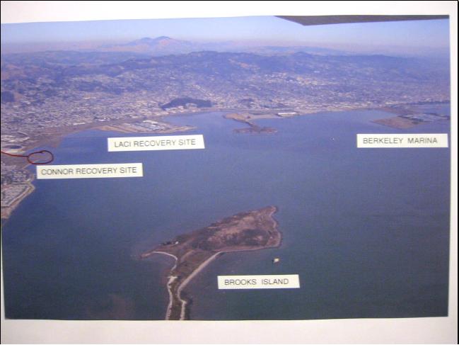
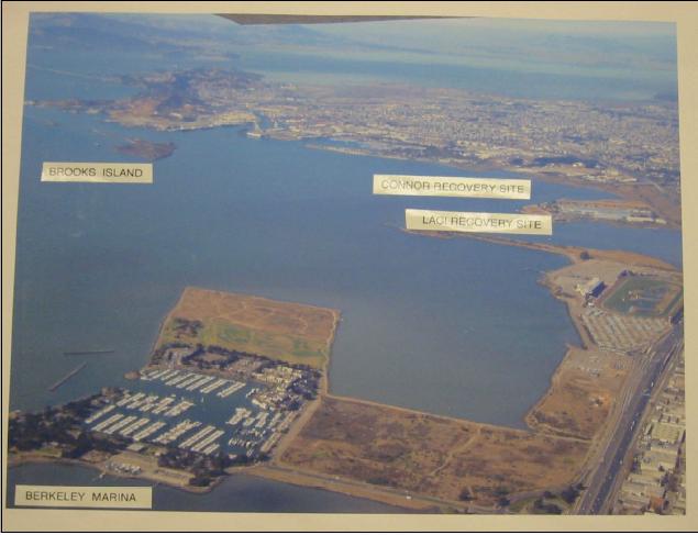
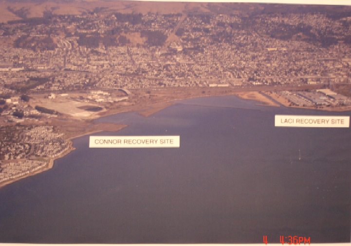
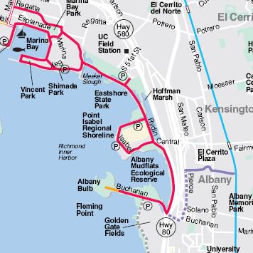
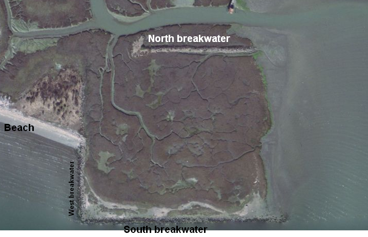
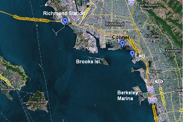
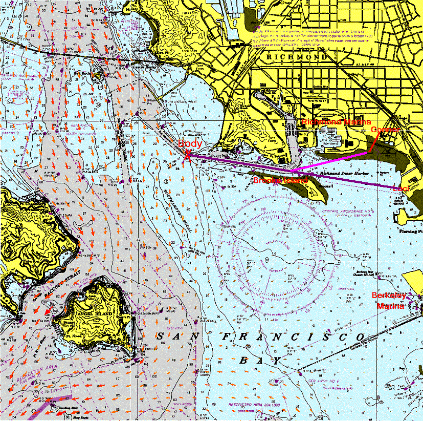
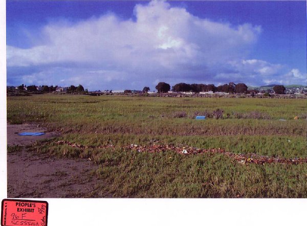
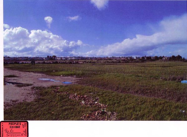
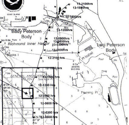
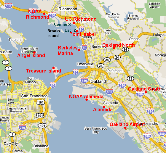
The location where Conner was found is called the 'Conner Recovery Site' in the trial testimonies. SII refers to this site as the Richmond Jetty. People's 97A, 97B, and 99 show the Jetty in relation to other case-relevant sites: Brooks Island, Laci Recovery Site (Point Isabel) and the Berkeley Marina. Click to enlarge.
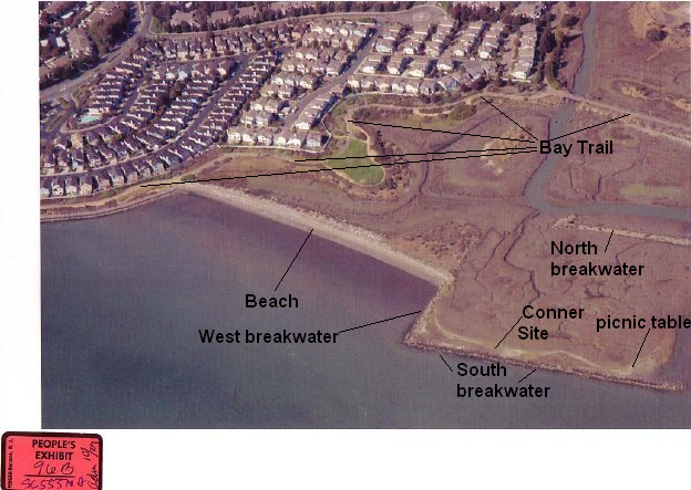
The Richmond Jetty is part of a large mud flat, which includes Meeker's Slough and the Stege Marsh. The breakwaters were built in the 1950s -- not only the west and south breakwaters on the Jetty but also the much larger breakwaters to the East, between the Jetty and Point Isabel. These breakwaters protect the wildlife habitat from high tides and erosion from wave action. People's 96A also shows the breakwaters to the East of the Jetty. The third picture shows the Bay Trail course for pedestrians and bicyclists, which makes the Jetty accessible by bike or foot from Point Isabel. The circled P indicates available parking for access to the Bay Trail. Click to enlarge.
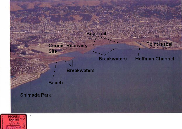
Parking is available at Shimada Park.
![]()
People's 96B and 96C show more detail of the Jetty. You can see the Meeker's Slough Channel that feeds many of the creeks and ponds that remain between high tides. In 96C, the tide is so low that you can see the sloped part of the South breakwater.
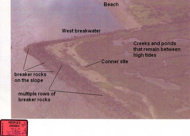
This aerial better shows the creeks and ponds that are fed by the Meeker's Slough Channel, and that are always present on the Jetty. Creeks are also fed from the East side of the Jetty as the tide rises. Click to enlarge.
Basics about Tides in the San Francisco Bay
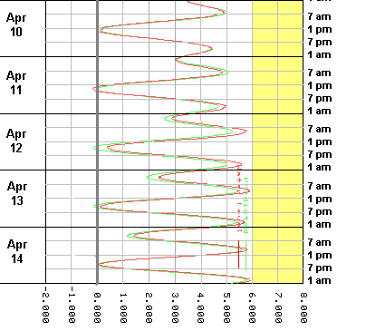
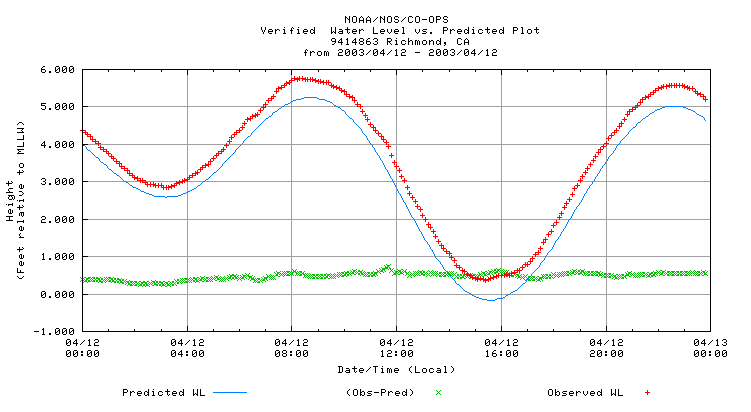
Every 25 hours, the Bay experiences two high tides and two low tides. When the tide comes in, the water level rises, but the two high tides are not equal -- they do not produce the same water levels, as demonstrated by this plot. One is called the higher high tide, because it produces the highest water level of the two high tides. Certain phases of the moon and certain times of the year produce higher tides than other times. Similarly, when the tide goes out, the water level drops, but the two low tides are not equal -- they do not drop the water to the same level. One is called the lower low tide, because it produces the lowest water level of the two low tides. Because of the 25-hour cycle, each day the tides come in and go out at different times.
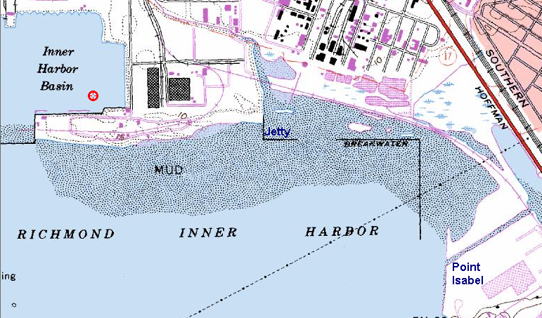
The NOAA, a federal agency, collects, verifies, and publishes water level data that is necessary to determine if Conner washed ashore. The NOAA prepares predictions for both the Richmond Inner Harbor (Richmond Jetty) and Point Isabel, but does not have a data collector at either of those sites. The data collection site closest to Scott's fishing route and the two Recovery Sites (Richmond Jetty and Point Isabel) is the 9414863 Richmond, Chevron Pier station. As a quality control, we compared the predictions for the Richmond station to those for Richmond Inner Harbor and Point Isabel over a 4-day period from September 29 - October 2, 2005. The time differences for the peak low and high tides were nominal, with no more than a 2-minute difference for the Inner Harbor and no more than 5 minute difference for Point Isabel. The water level differences likewise were nominal, with no more than a half inch difference for the Inner Harbor and barely more than an inch difference for Point Isabel.
This map shows the location of the 9414863 Richmond station, with place markers for the station, Conner site, and Laci site. Click to enlarge.
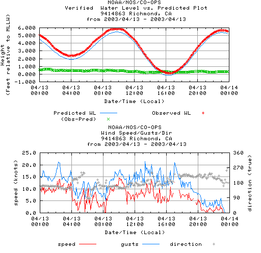
The NOAA publishes verified 6-minute water levels for 9414863 Richmond station. We have retrieved the plots for every day from December 24, 2002 through April 14, 2003 and combined them into a single plot, which provides an excellent visual of the differences in the water levels produced by the tides. The plot shows both the Predicted Water Level, and the the 6-minute Verified Water Levels, so you can see how accurate the predictions are, as the two lines are often identical. Local events, such as heavy rainfall or droughts, which cannot be predicted, make the water levels higher or lower than predicted. For individual daily plots, click here. For precise verified water levels for each 6-minute measurement, click here.
The water levels on the plots are in relation to MLLW. The depths written on the maps provided by the SFPorts page are MLLW.
The NOAA averages out all of the high tides in the 19-year epoch to arrive at a MHW, and all higher high tides to arrive at a MHHW. This is the datum for the Richmond station:
May 1 2008 15:50
ELEVATIONS ON STATION DATUM
National Ocean Service (NOAA)
Station: 9414863
T.M.: 0 W
Name: RICHMOND, CHEVRON OIL PIER, CA Units: Feet
Status: Accepted
Epoch: 1983-2001
Datum
Value Description
---------
-------- --------------------------------------
MHHW
17.62 Mean Higher-High Water
MHW
17.02 Mean High Water
MLW
12.70 Mean Low Water
MLLW
11.57 Mean Lower-Low Water
The average high tide (MHW) is 17.02, which is 5.45 feet above MLLW (17.02-11.57). The average higher-high tide (MHHW) is 17.62, which is 6.05 feet above MLLW (17.62-11.57). Only the Spring tides produce water levels above the MHHW of 6.05 feet. The plot is color-coded yellow to highlight the water levels from 6-8 feet, the ones above the MHHW (6.05 feet above MLLW), to visually demonstrate when the tides produced above average water levels.
This little clip from the plot shows that even with all of the rainfall from the storm, the tides on April 12-14 were below the MHHW, below average. This was the "heavy storm surge" that Distaso referenced in his closing arguments.
Closing Argument: Rick Distaso
He came ashore on a heavy storm surge.
The NOAA also publishes meteorological data for the Richmond station for the period December 24, 2002 through April 14, 2003, as well as actual water temperatures.
The Jetty does not fill with water at every high tide
HARRIS: Did he also mention that this particular area under high tide is under water?
OPDYKE: Yes. Yes.
HARRIS: Completely under water?
OPDYKE: I'm not sure that I have been there at the peak of high tide, but I have seen it under water at the, at the areas of the breakers, where the large rocks are. But I didn't pay that close attention to it prior to this time.
<<<<
HARRIS: Now, is there a difference between the photograph that you have there, People's 100, and what's up there, 96 E?
OPDYKE: There is, yes, there is a difference.
HARRIS: What's the difference?
OPDYKE: There is quite a bit of water covering the, the area that we're looking at in 96 E.
HARRIS: Let me take this from you and put it up on the screen. Does this appear to show that area that we've been talking about when it's at high tide?
GERAGOS: There would be an objection. He already testified there's no foundation for that.
JUDGE: Well, he can leave out the "high tide."
HARRIS: Does this appear to depict the location we've been talking about when it's pretty much under water?
OPDYKE: Yes.
HARRIS: Showing you a photograph that's previously been marked as 100. Do you recognize that?
GARD: Yes.
HARRIS: Go ahead and project that one up on the screen. Is this a photograph depicting the area where Conner's body was found, while it's underwater?
GARD: Yes. That would be an accurate depiction of high tide in the same location.
HARRIS: And when you were there it was low tide. High tide, do you know if those, if it fills up with water, if you know?
LOOBY: It, yeah, it fills up.
Opening Statement: Rick Distaso
Here's the location where Conner Peterson's body was found. There is a tidal flat. If you are at high tide, it's covered in water. At low tide it's flat ground. You are going to see this is all tidal flat. There is a walking path here. There is nowhere to drive down. You can't drive a car down to this particular location. You can walk along the beach here, at low tide. Then low tide, you can walk out onto the flat. But high tide it's mostly covered in water.
>>>>
Here is where Conner's body was recovered. The reason that this is dark on this chart is because that's those, it's a tidal flat. That means it's land in low tide, it's water in high tide.
>>>>
The body is found behind the jetty right here in this particular tidal flat. Next picture. This is a picture that was taken later, not on the day Conner's body was find, was taken to show you what the tidal flat looks like at high tide. You can see the residue line is just barely exposed. Come down, there is no waves breaking over the jetty, but this entire flat is covered with water at about, I think it's about a foot and half, two feet deep.
Closing Argument: Rick Distaso
Remember that area where he came ashore is a tidal flat, so at high tide it's covered with water all the way. At low tide it's ground. He came ashore on a heavy storm surge.
When People's 100 was first offered to the Court, Mark Geragos did not demand to know the date and the time the photograph was taken, nor the water level or the wind conditions. That was ineffective assistance of counsel, because the claim that the Jetty fills with water at high tide was a crucial element in the State's claim that Conner washed ashore.
Let's get some facts on the table. This chart is from the NOAA's verified 6-minute water level data for the time period Distaso and Harris were at the Jetty, approximately 12:44 to approximately 1:15. The "Pred 6" column gives the predictions, and the "Vrfy 6" column gives the 6-minute verified data.
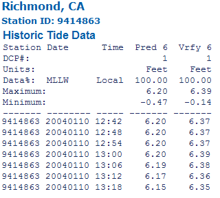
The tide peaked at 1:00 with a water level 6.39 feet above MLLW. Let's compare this water level to some other key water levels.
|
5.45 feet |
Average of ALL high tides (MHW) |
|
5.88 feet |
Water level produced by high tide that allegedly washed Conner ashore |
| 6.05 feet | Average of all HIGHER high tides (MHHW) |
| 6.39 feet | Water level produced by high tide on January 10, 2004 (People's 100) |
6.39 feet is not only higher than the water level that allegedly washed Conner ashore, it is also higher than the average of all higher high tides. Using the data from the NOAA for high tides for the period from December 24, 2002, to April 14, 2003 we can see how often the Jetty experienced an average higher high tide as well as the 6.39 tide for January 10, 2004.
217 high tides recorded
46 high tides (21%) at or above 6.05 feet
33 high tides (15%) at or above 6.39 feet
Distaso and Harris had the audacity to tell the Jury that People's 100 represented what the Jetty looks like at high tide when 85% of all high tides were below 6.39 for the period from December 24, 2002 and April 14, 2003.
That's not Marlene Newell's opinion. That's information straight from the NOAA. 85% of all high tides were below 6.39 for the period from December 24, 2002 to April 14, 2003.
Wind was not a factor on January 10, as Grogan reported the "seas were very calm." The NOAA Richmond station has wind data, which shows Grogan was correct.
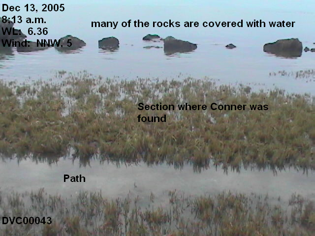
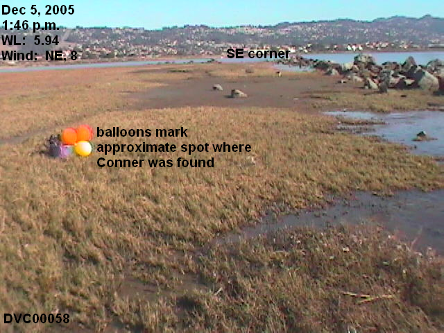
Now let's look at some pictures with water levels ranging from 5.45 feet to 6.39 feet to see how much difference the higher water levels make in the specific area where Conner was found. These were all taken on days with equivalent or stronger winds than on January 10, 2004. This is what the area where Conner was found looks like at 6.36 feet, compared to 6.11 feet, and then to 5.94 feet, so you can see the difference.

Distaso deliberately deceived the jury by presenting Exhibit 100 as evidence that the Jetty floods at every high tide, when, in fact, the Jetty, and specifically where Conner was found, looked nothing like it at all on April 13, 2003. That is prosecutorial misconduct.
Exact Location where Conner was found
Officer Brian Gard, Richmond Police patrol evidence technician, measured the exact location where Conner was found.
HARRIS: Now, when you, to go through the, the process. You went through and you made these measurements, so you obviously went over and looked to see where this body was at?
GARD: Yes.
HARRIS: Did you also photograph the body?
GARD: Yes, I did.
>>>>
GARD: The measurements were 73 feet east of the west edge of the breaker line.
>>>>
GARD: Yes, your Honor. This, this is the west edge breaker line. This is the south edge breaker line. Conner was located 73 feet east, which is this direction, of this breaker line. And then 326 feet this direction here, and 24 feet. So 326 feet this way, 73 feet this way, and 24 feet in this way. And that's where Conner's body was located.
Gard gave these measurements to Detective Soler, who prepared People's 101.
HARRIS: A chart that counsel has seen. Officer Gard, I'm going to leave this up here with you and ask you a few other questions. At some point in time during the time that you were there, did Detective Soler come out to the scene?
GARD: Yes, he did.
HARRIS: And did he also kind of process it in somewhat of the same way that you're referring to?
GARD: Yes, he did.
HARRIS: Now, if you could look at what you have before you, People's No. 101, did he take some of the information that you were just describing with the measurements of the 74 feet and, excuse me, the 73 feet and the 24 feet and incorporate, incorporate that into a diagram?
GARD: Yes, he did.
GERAGOS: Objection. That calls for speculation as to what Soler did.
JUDGE: If he knows. Did you see him do it?
GARD: I didn't see him do it, your Honor, but he showed me the diagram, said it was based on my measurements.
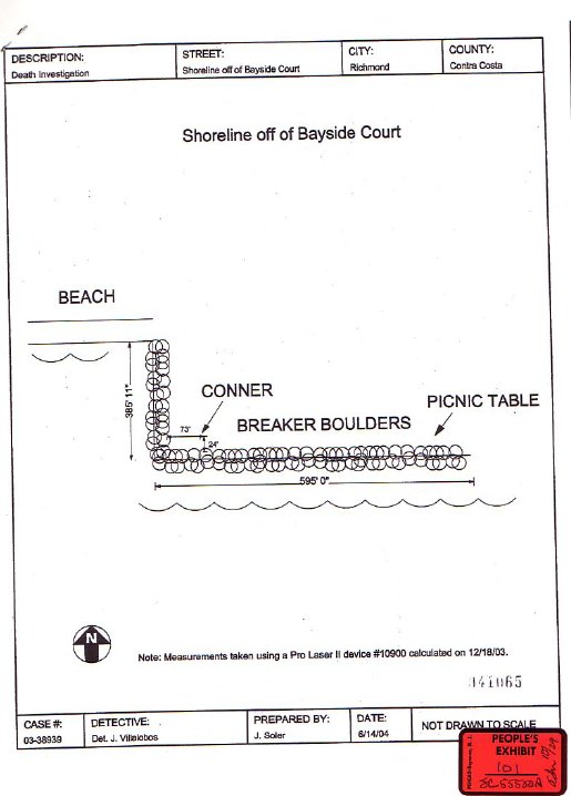
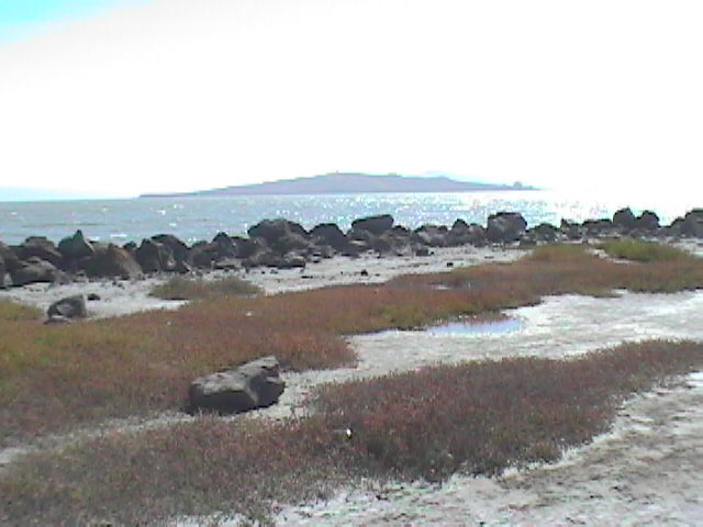
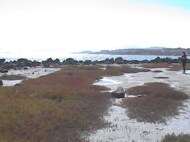
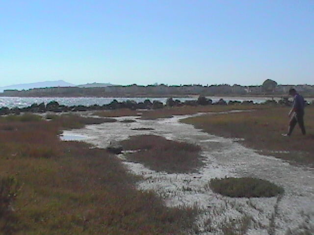
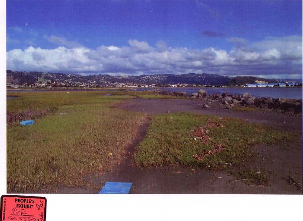
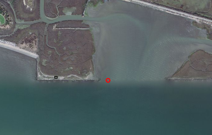
On July 11, 2004, PWC made a field trip to the Richmond Jetty to determine Conner's location, according to People's 101. These are pictures we took of the general area after marking off 73 feet from the inside of the west breakwater and 24 feet from the inside of the south breakwater. The rock in the 2nd and 3rd pictures marks the approximate location.
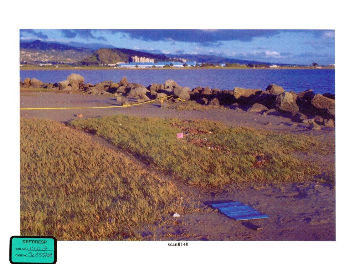
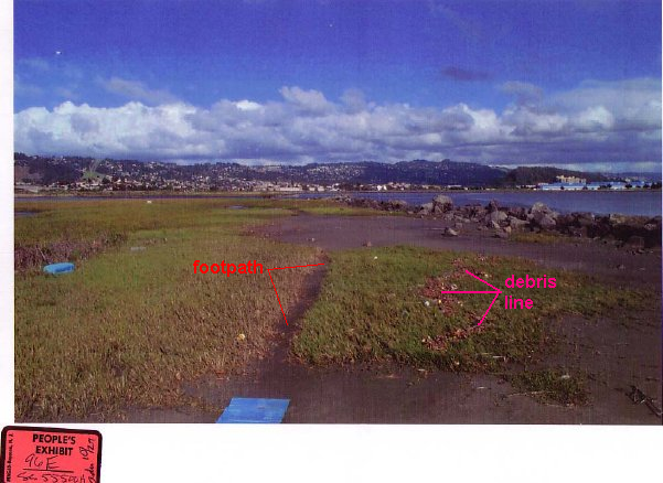
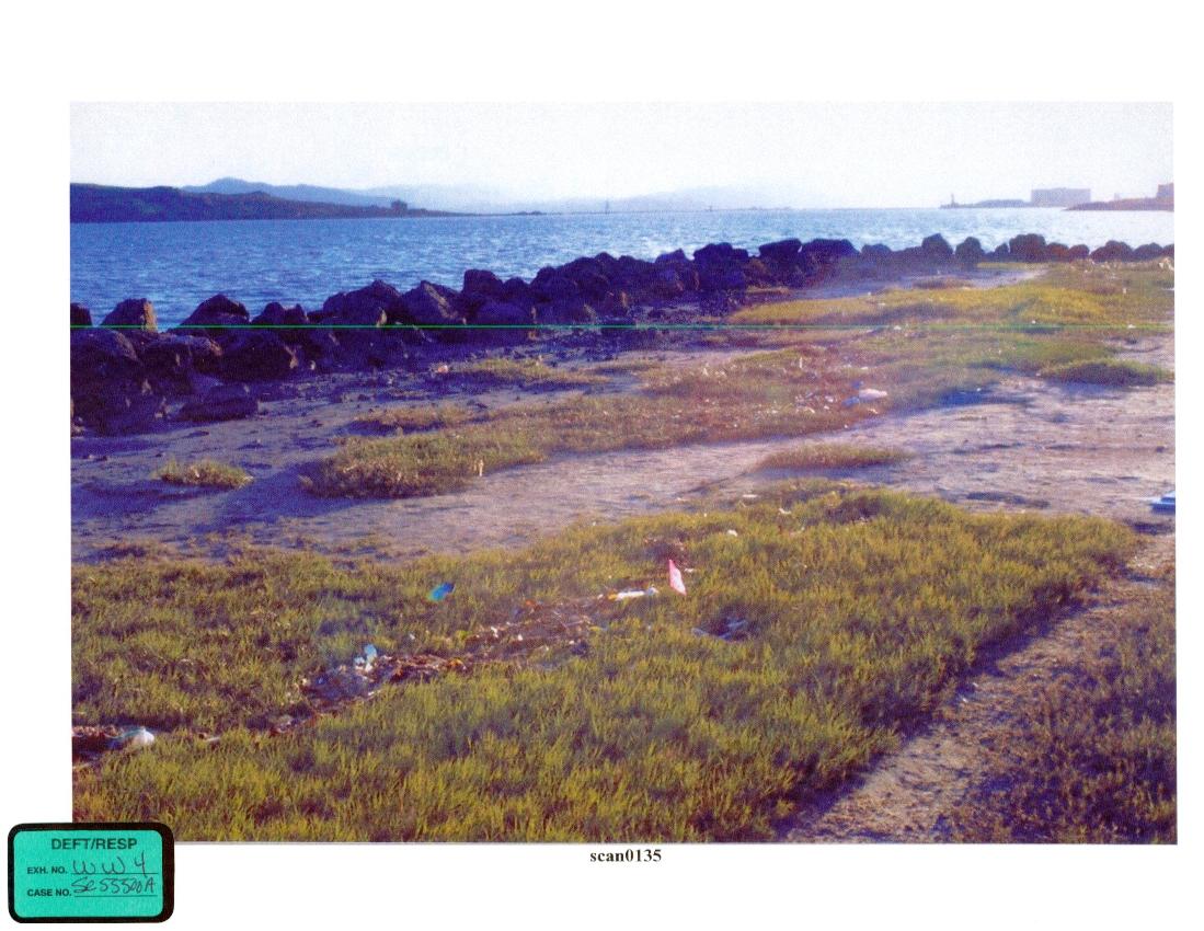
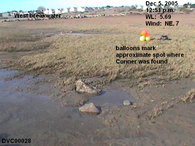
When comparing our pictures with the photographs Gard took on April 13, however, we realized we had identified the wrong location. People's 96E and Defendant's W-2 show a very distinctive section of grass. Gard testified that Conner was found between the debris line and the path. W-2 has a pink flag positioned at the exact spot. On People's 98A, Gard indicated where the picnic table was located, and Officer Opdyke indicated where Conner was found. Soler confirmed the location marked by Opdyke.
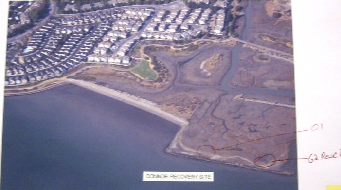
We've prepared a Google map showing the approximate location according to People's 101 and the correct location, according to People's 96E and Defendant's W2, with People's 98A as an inset so you can compare the landscape.
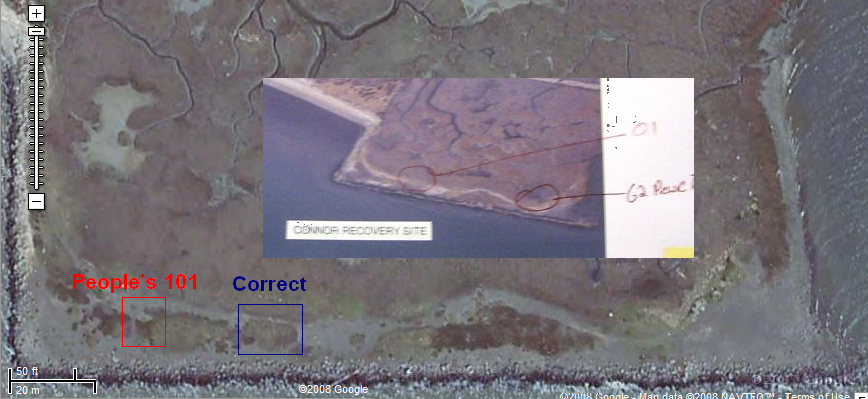
We conclude that Gard measured 173 feet from the west breakwater, but mistakenly wrote 73 feet in his notes. Note, both the west and south breakwaters do not form a straight line. The measure line on the Google map is positioned at the outside of the west breakwater. The breakwater itself is a couple feet wide.
Alternate Theories where Laci and Conner were in the Bay
Three theories attempt to explain where Laci and Conner were in the Bay: 1) The State's Fishing Trip theory; 2) Gene Ralston's Shipping Lane theory; and 3) and Matt Dalton's Albany Bulb theory.
The State's Fishing Trip Theory
The State convicted Scott on the fishing-trip theory, arguing that Scott dumped Laci's pregnant body in the Bay along his fishing route on December 24, 2002. This is the diagram Ralph Cheng produced to show the location of Laci's body and the trajectories she and Conner followed to wash ashore.
Click to enlarge.
Gene Ralston's Shipping Lane Theory
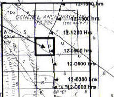
Many who believe Scott is guilty hold to the Shipping Lane theory. Based on Gene Ralston's alleged location of a body in the shipping channel near Richmond on March 13, 2003, they say where the bodies were found is right where they would have washed up. SII has prepared a chart showing the wind conditions juxtaposed with the water levels for the period from March 13 through April 14, 2003. The wind information was obtained from the LA Times and is for the Oakland Airport. Water level data is for the 9414863 Richmond, Chevron Pier station. Ralston Theory
Click to enlarge.
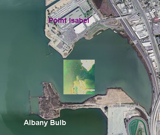
Matt Dalton's Albany Bulb Theory
Some who believe Scott is innocent hold to the Albany Bulb theory. Matt Dalton, then associated with the Geragos Law firm, did an experimental launch of three buoys from the Bulb, and one landed precisely where Laci's body was found. This image shows the Albany Bulb with the float test as an inset. The Bulb is a difficult terrain to walk, much less to carry a body the size of Laci, and there is no road access to the points where Dalton launched the buoys (Albany Bulb Field Trip). The second picture shows the trajectory (the red circle) proposed for Conner by another Scott-supporter. The little black square is where Conner was found. Click to enlarge.
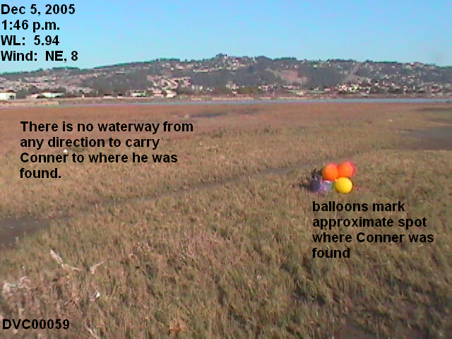
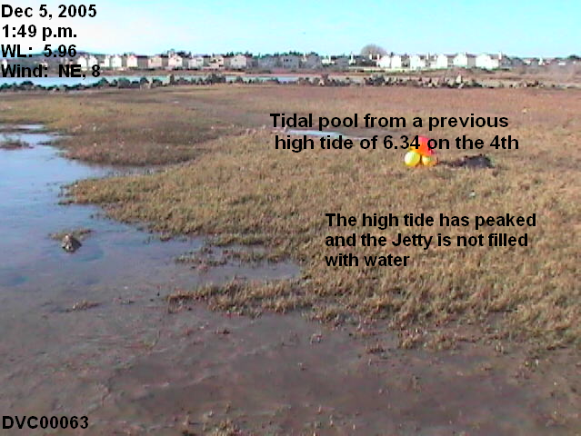
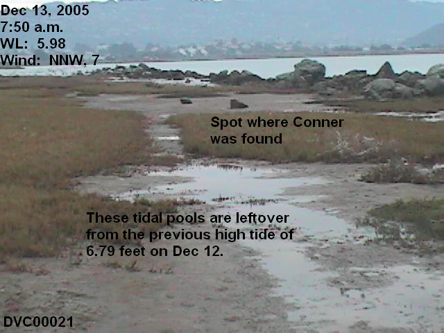
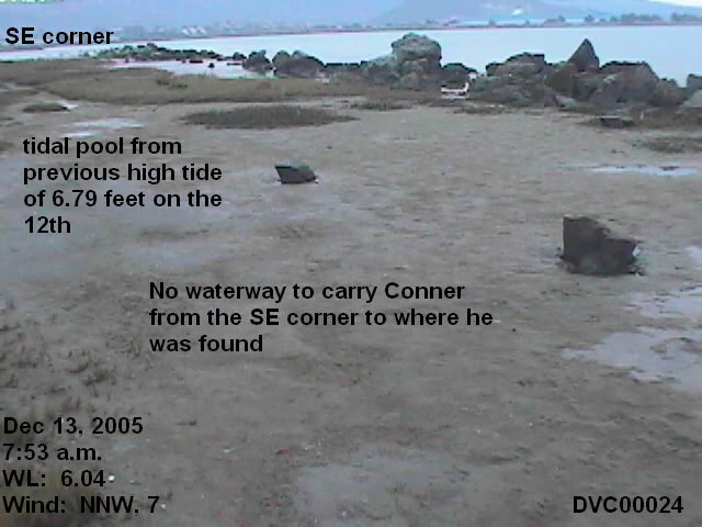
No Waterway existed from any direction to carry Conner to where he was found
As noted above, Officer Gard said that Conner was found between the debris line and the path. In Defendant's exhibit W-2, a flag was placed to mark the exact spot. This put Conner beyond the debris line.
Distaso explained why Conner was beyond the debris line.
Doctor Cheng is going to tell you the way things wash up with the tide, as the tide's receding heavy items are deposited first. They come over with the waves. As the tides recede, the heavy items settle first, and then the lighter items settle last. As the tide recedes, you can see that's what happened. Here's Conner's body. Obviously heavier than these areas of sea grass, and what not, debris, trash. And he's right ahead of it. (Opening Statement)
In fact, when you go back and look at the pictures, you can see the line of debris where the heavier objects settled first and, you know, the lesser heavy objects, as the tide was receding. (Closing Arguments)
For Conner to rest where he was found, according to Distaso's description, the water had to be deep enough to carry his body to at least where he was found before the tide began to recede, which was 24 feet inland from the south breakwater, and 173 feet from the west breakwater. Conner was found at 4:45 p.m. on April 13, 2003. The previous high tide peaked at 10:06 a.m., with a verified water level of 5.88 feet above MLLW. The 10:06 a.m. tide was a below average higher-high tide, as it did not equal the 6.05 MHHW.
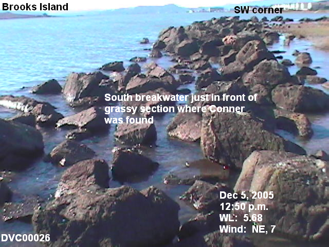
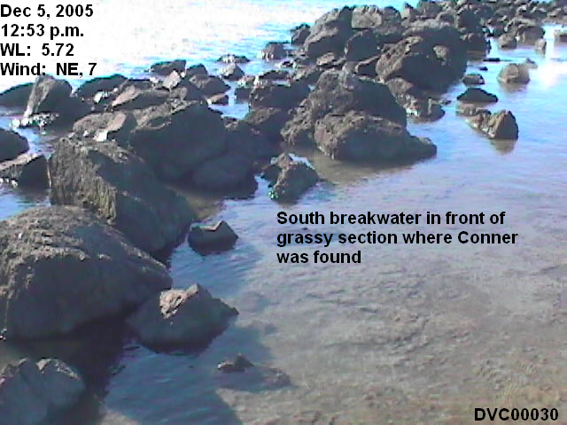
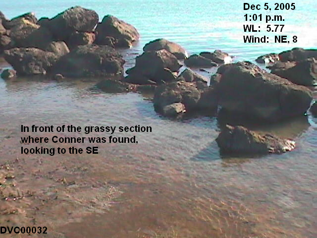
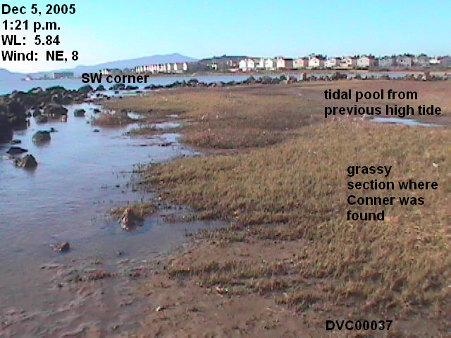
These six pictures taken on December 5 and 13, 2005, show that no waterway exists at water levels up to 6.11 feet that could carry Conner to where he was found.
Wind does make a difference in how much water is let onto the Jetty. Strong winds make stronger, higher waves, which push more water through the rocks as the tide rises and even as it recedes.
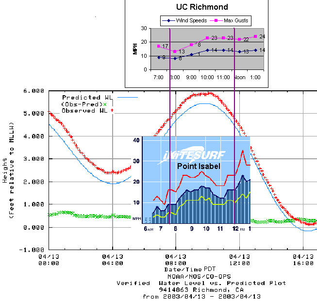
The first chart shows the NOAA 9414863 Richmond station verified 6-minute water levels for that high tide (5.88 feet above MLLW), juxtaposed with the wind conditions for the UC Richmond station and the Point Isabel station, two wind sensors close to the Conner recovery site. The second chart is the water levels with the wind data for that same station. Click on charts to enlarge. The data for the 9414863 Richmond station gives the highest wind reading when the high tide peaked at 17 mph, with gusts to 21 mph. UC Richmond data gives the wind speed at 14 mph with maximum gusts up to 23 mph. For Point Isabel, the winds were 17 mph with gusts up to 25 mph. (NOTE: 1 knot = 1.15 mph). On the 13th, winds were from the SW.
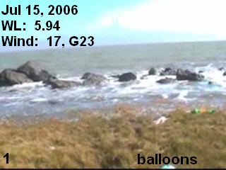
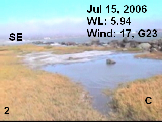
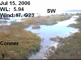
This is the water level and wind charts for July 15, 2006. The 9414863 Richmond station did not have its meteorological sensors in operation at that time. UC Richmond data gives the wind speed at 10-12 mph, with maximum gusts up to 18 mph, and from the South. Point Isabel shows stronger winds preceding the high tide, up to about 17 mph, and stronger gusts also, about 23 mph, with even stronger winds and gusts just after the tide peaked. That is verified in the video clips, that the winds were gustier after the tide peaked. NOAA predicted the water levels to reach 5.92 with this high tide, and the Preliminary data came in at 5.92. However, verified water levels shows the water level reached slightly higher, peaking at 5.94.
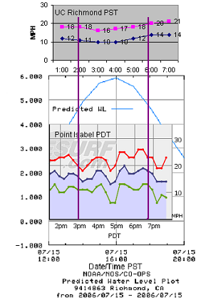
Thus on July 15, 2006, the water levels were higher than on April 13, 2003, and the winds were comparable.
These three pictures, taken from video clips, show that this combination of wind and water level put as much water onto the Jetty as the 6.11 water level did at mild winds. Even so, no waterway exists to carry Conner to where he was found. Click here to see the videos.
The Debris Line: Exonerating Evidence
With no waterway to carry Conner to where he was found, another possibility is that he was pushed there by the breaking waves.
The Debris line at the Conner Recovery Site is a very significant piece of evidence which fully exonerates Scott Peterson. Unfortunately, the State gave the Jury misinformation concerning how the debris line is formed, and the Defense Counsel failed to correct it. The Defense also failed to call an expert in tides to tell the Jury how a debris line is formed and to provide a visual demonstration.
The State established, through its own witnesses and its own exhibits, that Conner was found beyond the debris line. This is from the Testimony of Timothy Brian Gard, a crime scene investigator for the Richmond Police. Direct examination is by ADA David Harris.
HARRIS: Starting with 96 E, can you describe for us what we're looking at?
GARD: That, the photograph is taken from the orientation of a view from the west side of the area towards the east. In the center of the photograph is a small dirt foot path. To the right of the foot path, which would be south, there's leaves and trash, which is a debris line. And between the path and the debris line in the grass is where Conner's body was located.
>>>>
HARRIS: Now, the photographs that you have in front of you right there, 102-A through I, what's depicted in those photographs?
GARD: It's the body of Conner in the grass just north of the debris field.
This is People's 96E-G, showing the debris line and the path from different angles. The last picture is my annotation on 96E. Click to enlarge.
Defense WW1-4 are pictures taken after they placed a flag to designate Conner's exact location. Click to enlarge.
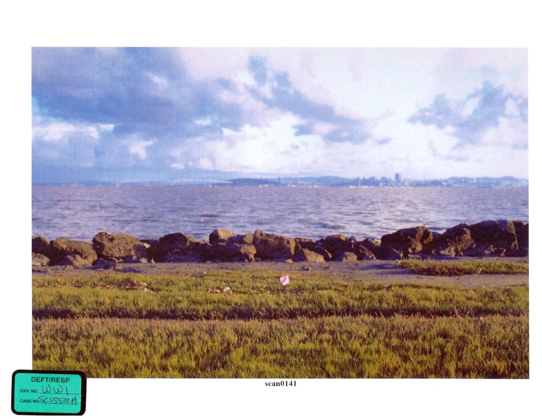
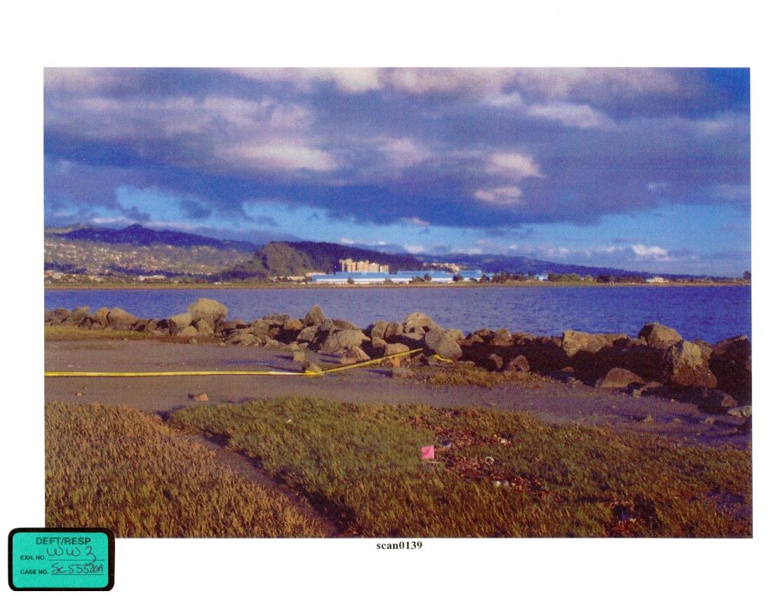
HARRIS: Like to show you two other photographs previously marked as WW2 and WW4. If you would look at that, see if you recognize what's depicted in it.
SOLER: Yes, I do.
HARRIS: And what is it that's depicted in these two photographs?
SOLER: Both of them are photographs of the general scene where the Baby Conner was found. WW2 is a general view from the angle northwest, looking in a southeasterly direction. And WW4 is a view of an angle from the northeast looking in a southwesterly direction.
HARRIS: Do these photographs depict the scene as you observed them on the 13th?
SOLER: Yes, they do.
HARRIS: Is there something in the, something in the photographs that depicts something of an evidence ID device?
SOLER: Yes. Both of them have that.
HARRIS: And what is that this?
SOLER: In the middle of the photographs, it's a flag on a metal stick. That flag is used to identify the location of any item of evidence that may not be seen because of tall grass, or just distance that you are away from the object when you are taking the photograph.
>>>
HARRIS: And the flag that you were just describing, that's in this location right here?
SOLER: That's correct.
HARRIS: Showing you WW4. Again, towards the middle of this photograph, is that that flag as well?
SOLER: Yes.
>>>>>
GERAGOS: And specifically when you went out to the location there was one picture here that was WW 2, was that a picture that you took?
SOLER: I believe it is, sir.
This second testimony is from Tod Opdyke, Richmond Police.
GERAGOS: This got one just looking straight out. WW 1. I assume you saw when they put a little flag in there.
OPDYKE: Yes.
GERAGOS: That's to mark where the baby was?
OPDYKE: Yes, sir.
Michael Looby, who found Baby Conner, confirms the accuracy of the flag's placement.
GERAGOS: Okay. Show them up this way. This is WW-1. If I tell you this is where the baby was, does that ring a bell? Where the flag is. And that this would be this mud area. And these are the rocks over here?
LOOBY: Yes.
The State tried to diminish the importance of the debris line, by pointing out other debris that was found in the same general area, and beyond Conner. However, Office Opdyke knew the difference, as he called the debris line in WW1-4 and 96E-G a "high tide water line."
HARRIS: Now, when you were talking about looking around this area, you can see in the photographs up there some things, and one of the witnesses described stuff as being debris. Did you notice if there was debris down in this tidal flat?
OPDYKE: There, there appeared, what I felt was a water line, maybe a high tide water line, and there was debris within this water line. Leaves, just articles of substance that appeared to, to have been washed up with, during the high tide. (underlining added)
How is the debris line formed? Not depositing items as the water recedes, as Distaso argued. In its Glossary of Coastal Terminology, the NOAA provides these definitions:
Debris line: A line near the limit of storm wave UPRUSH marking the landward limit of debris deposits.
Limit of uprush: The landward limit of UPRUSH at any given tide stage.
Uprush: The rush of water up the FORESHORE following the breaking of a wave, also called SWASH or RUNUP.
The debris line is what is formed as the waves push the debris ahead, not what is deposited as the tide recedes. The NOAA specifically says, it is the "landward limit of debris deposits." It is, as Opdyke described, a "high tide water line."
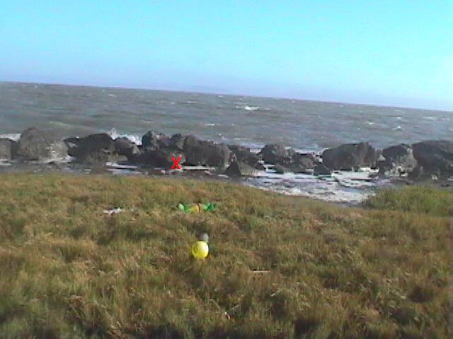
PWC made a field trip to the Richmond Jetty on July 15, 2006. In previous field trips, we had observed that a 5.88 foot water level would not be sufficient to carry Conner over the rocks in the south breakwater, so he would have to pass through the openings in the rocks, and that no waterway was present to carry Conner to where he was found. We wanted to see if an object the size of Conner could indeed get through the rocks and be pushed by the waves to where he was found. Our experiment included using a camcorder to record how items are pushed ahead by the breaking waves. As noted previously, the water level on July 15 exceeded that of April 13, and the winds were comparable.
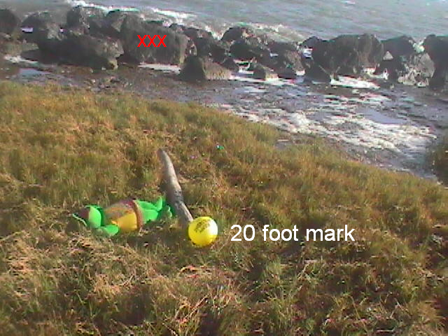
Two of our experimental objects did make it through the rocks onto the grassy section where Conner was found. Our video shows that they were not pushed further back than the lighter debris, and their final resting place was at least 5 feet short of where Conner was found.
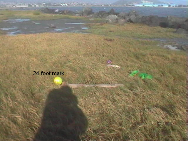
These pictures show the relationship of Kermit and the doll to the 24-foot mark from the nose-rock (marked with a red x). The log I used to measure is 4 foot long.
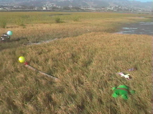
These pictures show that Kermit is less than 20 feet from the rectangle rock (marked with a triple red X), and shows the doll and Kermit in relationship to the 24-foot mark.
Click here to see the videos taken on July 15, 2006.
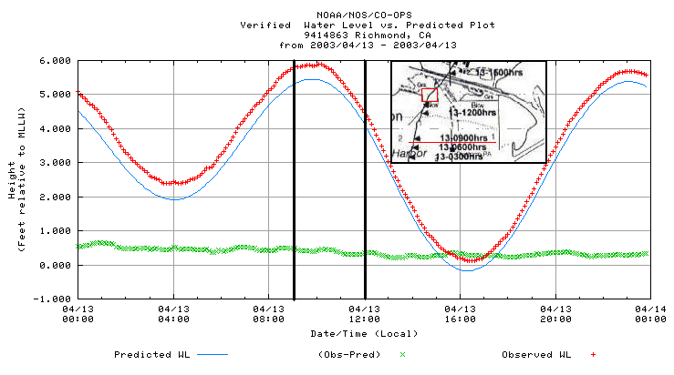
Some point out that Conner may have washed ashore in an earlier high tide, even perhaps the one during the storm on April 12, and the debris line was formed later. This chart shows the water levels produced by those high tides, and the wind conditions (maximum). I do not think it is reasonable to go back any further in time than April 12, not only because of the very long time Conner would have been exposed on shore, but also because all high tides from March 24 through April 11 produced water levels lower than the 5.77 of April 12.
| DATE | TIME | WATER LEVEL | NOAA Richmond | UC Richmond | Point Isabel |
| April 12 | 8:24 a.m. | 5.77 feet | 26 mph, G 32 | 20 mph, G 32 | 18 mph, G 27 |
| April 12 | 10:42 p.m. | 5.58 feet | 13 mph, G 24 | not available | |
| April 13 | 10:06 a.m. | 5.88 feet | 17 mph, G 21 | 14 mph, G 23 | 17 mph, G 25 |
| April 13 | 4:45 p.m. | Conner found | |||
These pictures prove that Conner could not have washed ashore to where he was found on the 10:42 p.m., April 12 high tide, which produced only a 5.58 foot water level. At 5.68-5.69 water level, far too many of the rocks are exposed and the water does not even come to the front edge of the grass where Conner was found. Strong waves would have thrown Conner repeatedly against the rocks, destroying his tender body. And you have the necessity of explaining how Conner could be on shore for 18 hours and not attract the attention of a single bird or insect.
During the high tide the morning of April 12, the winds were stronger, but the water level was lower than on the morning of April 13.
Again, you have the problem of Conner being thrown against these rocks by the strong waves. If he survived that, the water level still is not sufficient to carry him to where he was found. Moreover, you have to explain how he could be on shore 32 hours and not attract a single bird or insect.
The only reasonable conclusion is that Conner was not pushed to his resting place by the waves. He simply did not "wash ashore." The "most important fact" in the State's case is a lie.
Dr. Cheng's Progressive Vector Diagram is junk science
Distaso clearly identified the importance of Cheng's testimony to prove that the bodies washed ashore from Scott's fishing route, and the fundamental "facts" that his testimony established:
The defendant drives to his warehouse, opens up the door, backs his truck into that open space. I don't think I put a picture out for that, but that open space right where the boat was. He backs in, he unloads her into the boat, he shuts the door. Now he can do whatever he wants. He puts her, she's in the boat. He attaches the weights to her. >>>
The only reason these bodies were found, yeah, the defendant put them in the water with weights on them. >>>
The only reason those bodies were found is remember what Dr. Cheng testified to. There was an extremely low tide on February 12th (sic). And there was a very violent storm on February 12th (sic). That combination broke the, broke Laci Peterson free and sent her floating towards the shore. That's the only reason that those bodies were found at all. Not because of some magical frame-up job, or for any other reason.
And if that's the fact, and that's the evidence that was before you in this case, then that man's a murderer. It's as simple as that. (Note: Distaso misspoke February 12 for April 12) (emphasis added)
This is a very deliberate and precise claim by Distaso -- that Dr. Cheng proved to the Jury, beyond reasonable doubt, that a combination of an extremely low tide and a very violent storm broke Laci free from her weights and sent her floating towards shore, and that is all that was necessary to convict Scott Peterson.
Distaso did not misrepresent Dr. Cheng's testimony. This is how Cheng characterized the wind event on April 12, 2003:
I felt that was, wow, quite a wind event during that day. I really recall in my own mind, you can see now the scientific records showed us now during that particular period of time, in the morning, or starting from the midnight of the midnight April 11th, or early morning of April 12th, you can see wind exceeded 40 knots. 40 knots, wind exceeded. Also a sustained wind for long period of time, subsided slightly, but still continued on for another good twelve, eighteen hours with wind average around twenty knots per hour. So that is quite a magnitude of wind. And during that period of time, there was occurrence of a very low tide right after noon of April 12th.
Cheng explained that the wind produces energy and forms an orbital motion. Strong winds in shallow water will cause a wave motion with enough energy to churn the sediment on the floor of the Bay, causing a stirring action that can raise objects to the surface--that's the first phase. The second phase is the wind drift, which will move floating objects along the surface of the water. Cheng said this combination of strong winds and very low tides was necessary to dislodge Laci from her anchors, and send her to shore as a floating object. Because she was floating, he could apply the wind-drift formula provided by the Coast Guard to determine where she was when she loosed from her anchors.
But the critical element of his theory is that this all started with a negative low tide.
Basically we obtain the wind information, time series. We reconstruct, now, based on the U.S. Army Corps of Engineers Coastal Engineering Handbook, they give you certain formulas for certain given wind conditions. So how much actual water movement would be is not a windspeed- water movement here. And then you would reconstruct hour-by-hour here as if -- assuming the bodies started from here, you go backward rather than going forward here until certain -- to a certain time here. We -- of course, we assume that now the body would have started from Mean Lower Low Water. The reason we say that is now when the water depth is shallower, that is when the tidal condition was very low part of the water, that is the higher probability that energy will transmit to the bottom. Therefore, based on that, backtrack to that particular time that -- where the Mean Lower Low Water was negative, I assumed that was the location where the body is dislodged from what might be anchored to The Bay.
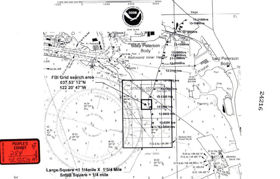
Cheng's efforts produced a chart (People's 284), which he called the Progressive Vector Diagram (PVD). He was asked specifically for his expert opinion on where the bodies had to be in order for them to wash ashore where they were found.
David Harris: Ultimately you gave this to the Modesto Police Department for them to come up with their search plan that you were discussing. Based on what you have been talking about, the energy and the lack of speed, so to speak, of the currents in that particular shallow area, where do you think -- in your expert opinion, where do you think those bodies had to be to reach that particular place that they were at?
Ralph Cheng: I think, based on those estimates, and based on the actual observation of the wind and the scientific judgment, that's the location I recommended. As let me address that as the highest probability that might have started from. It's not a deterministic prediction, but it's a highest probability.
David Harris: So looking --
Judge Delucchi: Can you show us on the map where you think they came from?
Ralph Cheng: I mean the little inner square. I recommended that they search for starting from this particular point.
Judge Delucchi: That's where you think maybe the bodies originated from?
Ralph Cheng: Yeah.
(emphasis added)
So, in Dr. Cheng's expert opinion, the little inner square is the location from where Laci's body dislodged and from where she and Conner began their journey towards shore. The little inner square is right along Scott Peterson's December 24, 2002 fishing trip. This fits in perfectly with the State's theory that Scott was dumping Laci's body, not fishing.
The Modesto Police Department placed so much faith in Dr. Cheng's high probability area that it relied on it exclusively to develop the "survey area" for the May, August, and September 2003 searches for the missing body parts and anchors.
Needless to say, Dr. Cheng's expert opinion had a profound impact on the investigation and the development of the case against Scott.
Serious Flaws in Dr. Cheng's Method
Cheng's method is seriously flawed: he could not produce consistent results, and he failed to familiarize himself with the recovery sites.
3His method did not produce consistent results
Cheng applied the wind-drift formula from the U.S. Army Corps of Engineers Coastal Engineering Handbook to the data from a time series wind chart. If you notice, the PVD charts a line from the little inner square to where Conner was found. It does not include a line from the little inner square to where Laci was found. That is because the method didn't work for Laci.
Mark Geragos: And just so that I'm clear, it's -- based on your formula and your trajectory, you could not do -- this did not work for Laci Peterson; isn't that correct?
Ralph Cheng: That is correct.
A scientific method that cannot produce consistent results should not have been allowed as evidence in a capital murder case. That just is not good science.
3He failed to familiarize himself with the recovery sites
Cheng said there were "large uncertainties" which caused the failure to produce consistent results. One of these uncertainties was not knowing the precise time that the bodies landed ashore.
Cheng simply did not do his homework. He should have consulted the verified water level data from the NOAA to determine the water levels on April 13-14, 2003, the dates the bodies were found. He should have gone to the two sites, armed with pictures of the placement of the bodies, and observed some comparable water levels. This would have been easy to plan, using the Tide Predictions provided by the NOAA.
Had he done his homework, he would have known that neither body could have washed ashore on just any day or at any time. Each required a certain water level in order to arrive at its particular destination. He could have looked at the very narrow window of time when those water levels existed on the 13th (for Conner) and the 14th (for Laci) and then started tracking back from those times.
That is good science -- to gain the knowledge necessary to remove as many uncertainties as possible. His failure to do so is inexcusable, given the easy access he had to both the information and the recovery sites.
Serious Flaws in Dr. Cheng's Data
Dr. Cheng's data is flawed to begin with. He obtained the exact location where Conner was found from the MPD, who obtained it from Officer Gard. As noted above, Gard incorrectly identified the spot as 73 feet from the west breakwater -- that is what he conveyed to the MPD and that is what he conveyed to Soler.
Since Cheng's Progressive Vector Diagram backtracks from Conner's location, starting off with the incorrect coordinates cannot possibly produce correct results.
Dr. Cheng never identified his source for low tides or wind data for April 12 that he used to produce the PVD. However, he did characterize them in his testimony. He claimed:
These are not incidental tidbits of information. They are fundamental to his conclusion. They are blatantly false.
3The truth about the low tide on April 12
Distaso used the phrase, "extremely low tide," and Cheng described it as a negative MLLW, which is a low tide that drops below the 0.000 line on the NOAA plots. A slight negative MLLW tide was predicted for April 12, 2003, but it didn't happen. Because of the rainfall, the water level was higher than predicted and did not drop below the 0.000 line. The blue line represents the predicted water level, and the red line represents what really happened -- the verified water level.
Cheng's mischaracterization of this tide as a "negative MLLW" demonstrates, once again, that he did not do his homework--he did not consult the verified water levels provided by the NOAA.
Furthermore, Cheng's timing on the PVD is way off. He specifically said that he tracked Conner's movement back to the time of the negative MLLW, and then told the MPD that was the area of high probability, where they were most likely to find the anchors or missing body parts.
However, the little inner square on the PVD indicates a time of 0900 hours on the 12th. 0900 hours is at the peak of the higher high tide on the 12th. Cheng says it was his intent to track Conner's body back to the time of the negative low tide so the MPD would know the best place to look for additional evidence, and yet he tracks Conner back to the time of the high tide.
Why didn't Cheng identify Conner's location at 1500 hours (3 p.m.) as the high probability area? Cheng obviously didn't know the exact time of the lower low tide because he stated in his testimony: there was occurrence of a very low tide right after noon of April 12th. Is 3 p.m. "right after noon"?
3The truth about the wind on April 12
Distaso called it a "very violent storm," and Cheng said it was "quite a wind event." Cheng said the storm included:
initial winds exceeding 40 knots (46 mph) [Note: 1 knot = 1.15 mph]
12-18 hours of winds averaging 20 knots (23 mph)
the lower low tide occurred during the 20 knot winds
Remember, both Distaso and Cheng argued that it was the combination of the very strong winds and the extremely low tide that caused Laci to be loosed from her anchors.
I have surveyed 11 wind sensor stations in the area surrounding where Conner and Laci were found (indicated by the green x's), and without exception, they all refute Cheng's and Distaso's descriptions. Even the wind pattern graphs made available by Cheng's own employer, the USGS, refute Cheng's claims:
The winds never reached 40 knots on the 12th
The winds did not average 20 knots for 12-18 hours on the 12th
The lower low tide on the 12th did not coincide with winds averaging 20 knots
When blatant, bald-faced lies are presented to a Jury as facts, something is very wrong.
The map shows the 11 stations surveyed, with the Conner and Laci recovery sites indicated. Click here to see the details. Moreover, the wind pattern graphs provided by Dr. Cheng's own employer, the U.S. Geological Survey (USGS), do not confirm Cheng's claims. Click here to see the USGS wind graphs.
3Wrong time for Conner to wash ashore
We have already noted that Cheng was given the exact location where Conner was found by the MPD, who received it from Officer Gard. Gard had written the distance from the west breakwater as 73 feet, which was incorrect. Thus, Cheng started at the wrong location.
He also started at the wrong time. Cheng said he determined Conner's trajectory by going backwards from where he was found, reconstructing the trajectory hour by hour, based on the wind conditions and according to the Coast Guard wind drift formula.
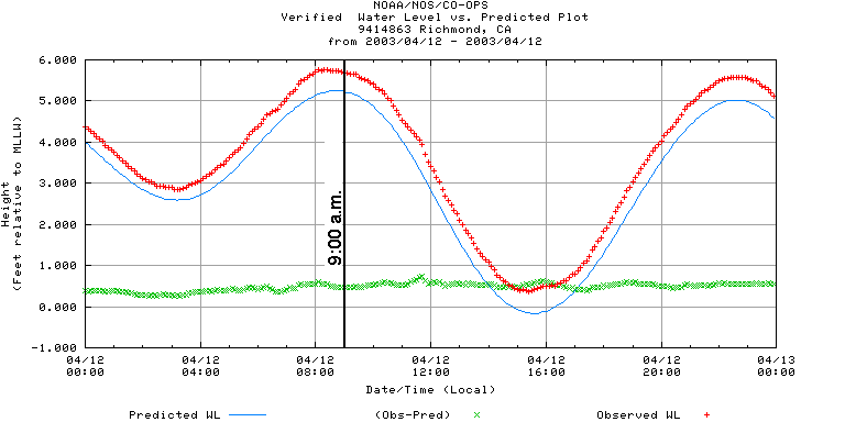
If you look at the upper section of the PVD, you can see that at 0900 hours on the 13th, Cheng still has Conner offshore. Even at 1200 hours, Conner is offshore. The high tide peaked at 10:06 a.m. I have put the PVD as an inset in the NOAA plot. The Jetty is outlined in red and the 0900 marker is underlined in red.
If Cheng had done his homework, what is expected of an expert, and visited the Jetty during various tides, he would not made such a blundering mistake. The only way Conner could get onto the Richmond Jetty after Noon on the 13th was to be put there by human hands.
Conclusion
The State had to prove that Laci and Conner washed ashore from where Scott put Laci on December 24, 2002. Distaso knew very well the critical need to establish the connection between Scott's fishing trip and the two recovery sites, and he so characterized it as "the most important fact."
Cheng's testimony is the only evidence the State produced to "prove" that Conner and Laci washed ashore. Cheng's analysis is seriously flawed, to the point of being junk science.
He used a scientific method that could not produce consistent results
He failed to familiarize himself with the recovery sites and the particular location of the bodies
He mischaracterized the lower low tide as a negative MLLW
He grossly exaggerated the wind conditions for April 12
He falsely stated that the lower low tide coincided with winds averaging 20 knots
He started from the wrong location
He had Conner coming ashore at a water level far too low to wash him over the rock breakwater
Furthermore, the State lied to the Jury when it presented People's 100 as evidence that the Jetty fills with water at high tide. It doesn't. For at least 79% of all high tides between December 24 and April 14, the Jetty did not fill with water.
Finally, we have empirical evidence that Conner could not have washed ashore from any direction under the conditions that existed on April 13. The water level produced by the 5.88 high tide simply did not produce a waterway to carry him to where he was found. And he was beyond the debris line, which means that he was not pushed back to where he was found by the breaking waves.
Conner did not wash ashore. Scott Peterson did not put a pregnant Laci in the Bay on December 24, 2002, or at any other time. Nor did anyone else.